This post is meant as an informative guide, for anyone who might be interested in cycling The Giant Circle route I created.
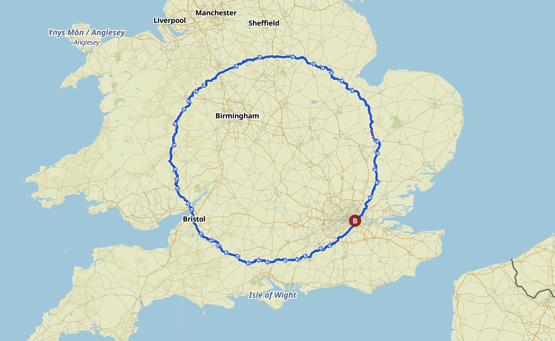
Perhaps you’re also curious to pedal the biggest circle you can ride in the UK. It might not be the absolute biggest in terms of total mileage, but the variation would be very small unless you started outside of London and compromised the geometry.
When I first created this 900km route, I was in the audax/ultra-distance mindset and considered it as a 3 day cycling challenge. As I fleshed out the route, I realised that it would actually be quite a scenic loop, and now – having ridden the route over 7 days – I believe this would be an enjoyable bike tour at a leisurely touring pace, over as many as 10 days or more. I put a lot of time in to balance out the overall shape with enjoyable and quiet country lanes, through some of the UK’s most scenic areas, so wanted to share this guide to riding it. If you do decide to ride The Giant Circle – please let me know!
Transport
The first thing to note is transport. I deliberately started this route in London, partly for convenience, partly as an antidote to the quiet country miles that make up the rest of the route, and partly for the sake of beginning at Greenwich with the coordinates 0.0, 0.0.
If you’re London based, the first third (heading clockwise) to Bristol is relatively well connected by train. From London there are direct trains to Godalming or Haslemere, Salisbury, Winchester and Bristol – all around 80 km apart.
From there, things are not so well connected, and the next direct train station to London is Stoke-on-Trent (slightly off the route) or Newark-on-Trent. In terms of both logistics and landscapes, it makes sense to divide The Giant Circle into 3 parts…

Part 1: London to Bristol
The first of these sections is the leg from London to Bristol. Please note that while I describe this route in a clockwise direction (because that’s what I had in mind as I designed it), there’s no reason why you can’t ride it anti-clockwise. Just keep in mind that the prevailing winds are generally from the South West.
The ride out of London is a slight slog, as it often is. Starting at Greenwich observatory is a nice beginning, particularly as you head south and leave the city views behind. The route begins with a stretch along the Waterlink Way from Greenwich, a traffic-free route along the Pool River which is part of the National Cycleway 21. After crossing South London you join the Surrey Cycleway which leads you through some beautiful lanes, past the first cute villages of the trip as well as the first punchy climbs.
At 75 km there’s an underwhelming section along the busy A3, but you’re on a roadside cycle path so the traffic is not a danger. There are nice off-road alternatives, but I tried to keep this route on tarmac wherever possible. The A3 is a bumpy affair, but it’s worth the push to join the A3 Cycle Route along Punch Bowl Lane. The Devil’s Punchbowl is a long climb – by far the biggest of this first section – towards a landscape formed as a result of glacial erosion during the last Ice Age, leaving behind an impressive view from the top.

At 120 km you reach New Alresford, a cute market town (you’re now in Hampshire) in an area famous for watercress. The lanes around here are lovely, especially along the section of the National Cycle Route 23 towards Winchester.
Winchester has direct trains to London, and the town is definitely worth a little exploring. Winchester Cathedral is one of the largest Gothic cathedrals in Europe, and the town is full of history. The River Itchen (which you’ll have followed for the last few miles) flows through town, and you cross it on the way in.
From Winchester there’s some lovely riding along the signposted National Byway – a meandering route following quiet lanes through some charming villages and takes you over the River Test.
Before you reach the National Cycle Route 24, there’s a short off-road section (one of the few of the route) which can easily be avoided at around 160 km. Once you join the NC 24, you’re led into Salisbury, which also has enough charm and history to keep a visitor entertained for a day. It would be a pity to miss the epic Cathedral.
From there you skirt to the northern part of Cranborne Chase AONB, along the River Wylye, continuing along National Cycle Route 24 until Warminster at around 200 km. You should hope that the winds are favourable as you head across the plains towards Bristol. At the edge of town you briefly meet EuroVelo Route 1 for the first time as you join the old Whitchurch Railway Path for a short section.
Part 2: Bristol to Newark-on-Trent
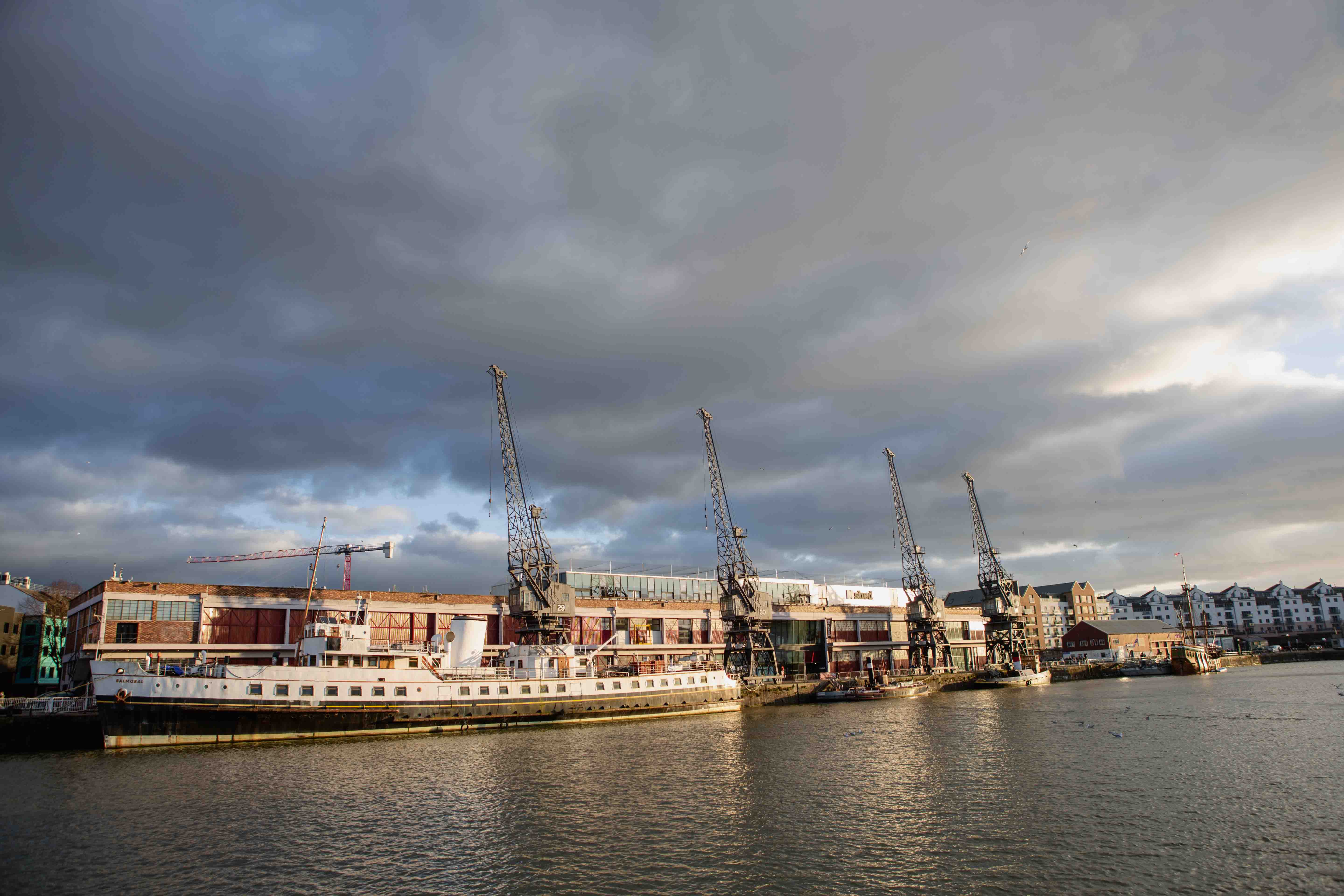
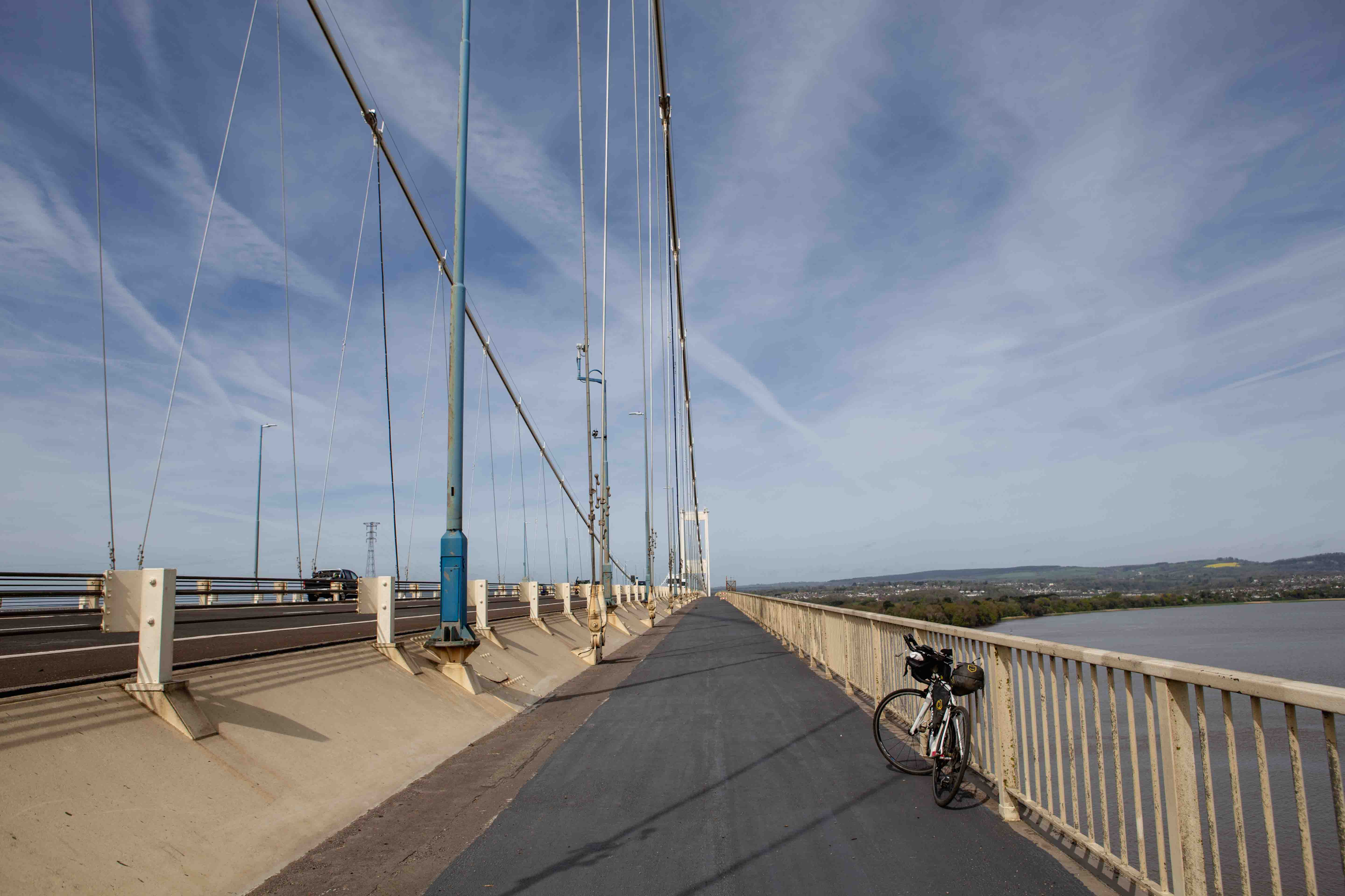
Bristol, home to half a million people, is around 265 km into The Giant Circle. There’s a lovely stream-side cycle through the Blaise Estate leaving town, before you head off to the Old Severn Bridge. Crossing the bridge at 290 km is one of the highlights of the trip, taking you from England into Wales. It’s an epic cycle, especially if it is windy!
Past Chepstow, you are given a warm welcome to the country with the first of a few really nasty climbs. If you are traveling with weight on the bike, you will be grateful for low gearing here. It’s a slog past St. Arvans, but you’ll be rewarded with lovely views behind you of the Severn Estuary.
It certainly feels different on the Welsh side of the estuary. Harder work on the legs, and longer sections between resupply. At 325 km you cycle right past White Castle, the best preserved of the Monmouthshire fortresses. In fact, from there you’re led along The Four Castles Route for a while, so be sure to check out Grosmont Castle before you return across the English border and continue north through Herefordshire.
At 360 km, after a few more leg-burning climbs, you cross the River Wye at Bredwardine Bridge, and then head north towards the Shropshire Hills for more beautiful riding. You’ll be pleased to find that the route slowly flattens once you’re past Church Stretton, and there are some much easier miles until you reach the Shropshire Union Canal at 480 km.

At 505 km you cross the Trent & Merseyside Canal and have the option of turning north towards Stoke-on-Trent should you need a train station. A slightly busier section follows, particularly along the Cheadle Road, which is an unfortunate necessity as you pedal towards the Peak District. It’s worth it, because as soon as you reach the National Park boundary and sign, the riding becomes really quite splendid again. Savour the stretch between Ilam and Tissington, which is delightful Peaks riding.
National Cycle Route 547 leads you to Carsington Water, where a car-free route skirts the reservoir’s edge. It’s off-road and hilly, but the gravel is easily rideable – even on a road bike – and the detour is worth it in my opinion, particularly for a scenic picnic stop. If you prefer, you can simply follow the main road instead.

At 585 km you’ll pass through Kirkby-in-Ashfield – a useful resupply town – before the hills finally start to ease up. 620 km in you finally reach Newark-on-Trent, where you can bid farewell to the hilly section.
Part 3: Newark-on-Trent to London
Newark-on-Trent is a historic market town in Nottinghamshire, on the River Trent (surprise, surprise). The geography changes significantly on either side of the river, which you’ll cycle over passing through town. Be sure to swing by the castle ruins which the route takes you directly past.
I really like the riding that follows: pancake flat through some incredibly peaceful lanes. If the wind isn’t in your favour, then it might not be quite so enjoyable. Spalding is at 690 km, and one of the larger towns you pass through on this section.
Not long after, you cross the Prime Meridian, and at 725 km you ride through Wisbech, which has seen better days. Welcome to the Fens, a large flat part of the country that will be your roadside views for a while. The Fens can be a surreal place – quite unlike anywhere else on The Giant Circle.
Perhaps a highlight of this section is riding through Cambridgeshire’s Ely, with its famous cathedral ‘The Ship of the Fens’ which dates back to the 11th century. Absolutely worth a visit. As you leave town, you continue along National Cycle Route 11 for around 15 km, bringing a dash of off-road riding with it. Fear not, the riding is easy and worth it for the peace and quiet. Don’t forget to look over your shoulder for a view back to town.
The gravel continues through Wicken Fen Nature Reserve, located in the heart of the Cambridgeshire Fens. It’s one of the oldest reserves in the country, and is managed by the National Trust. It’s now one of the largest remaining areas of natural fenland in the country.
Once you get past Newmarket, you’re almost at the final 100 km back into London. It’s more of the same until Thaxted in Essex, a picturesque town with some fantastic medieval architecture. Be sure to slow down and soak it in as you roll through town.
From here, I’m afraid the next 50 km are a bit of a slog towards London. You ride through Dunmow at 840 km, and then there’s a tediously straight Roman Road continuing South West. The road is fine to cycle, but it can be quite busy at the wrong time of day – especially after Chipping Ongar – if you find yourself there in rush hour. It can be a shock to the system after so many quiet miles in the countryside.
Take a moment at Havering-atte-Bower, 875 km, as on a clear day you can see the view across London’s skyline in the distance. Soak in the last greenery, as soon you’ll be pushing through the bleak suburbs of Barking and Dagenham.

After a while you’ll reach National Cycle Route 13 which keeps you protected from traffic while you’re sucked in towards the city. This stretch is really quite unpleasant, if I’m honest, but at least it is safe. As you ride towards the city skyline, accompanied by the drone of traffic, you’ll have the feeling that you’re being sucked into The Big Smoke. There are a few glimpses of nature as you cross the waterways that feed into the Thames, but even these feel dwarfed by the urban landscape.
This push is worth it for the route’s grand finale. Take a moment on Gallions bridge to see a plane fly in or out of London City Airport, before pedalling over to the free Woolwich ferry across the Thames. If it isn’t running, you can take the eerie pedestrian foot tunnel which is next to the ferry terminal. If you’d like something even more dramatic, you can cycle a short way past the Royal Victoria Dock and City Airport to the cable car that will happily transport a loaded bicycle over the Thames for a few quid.
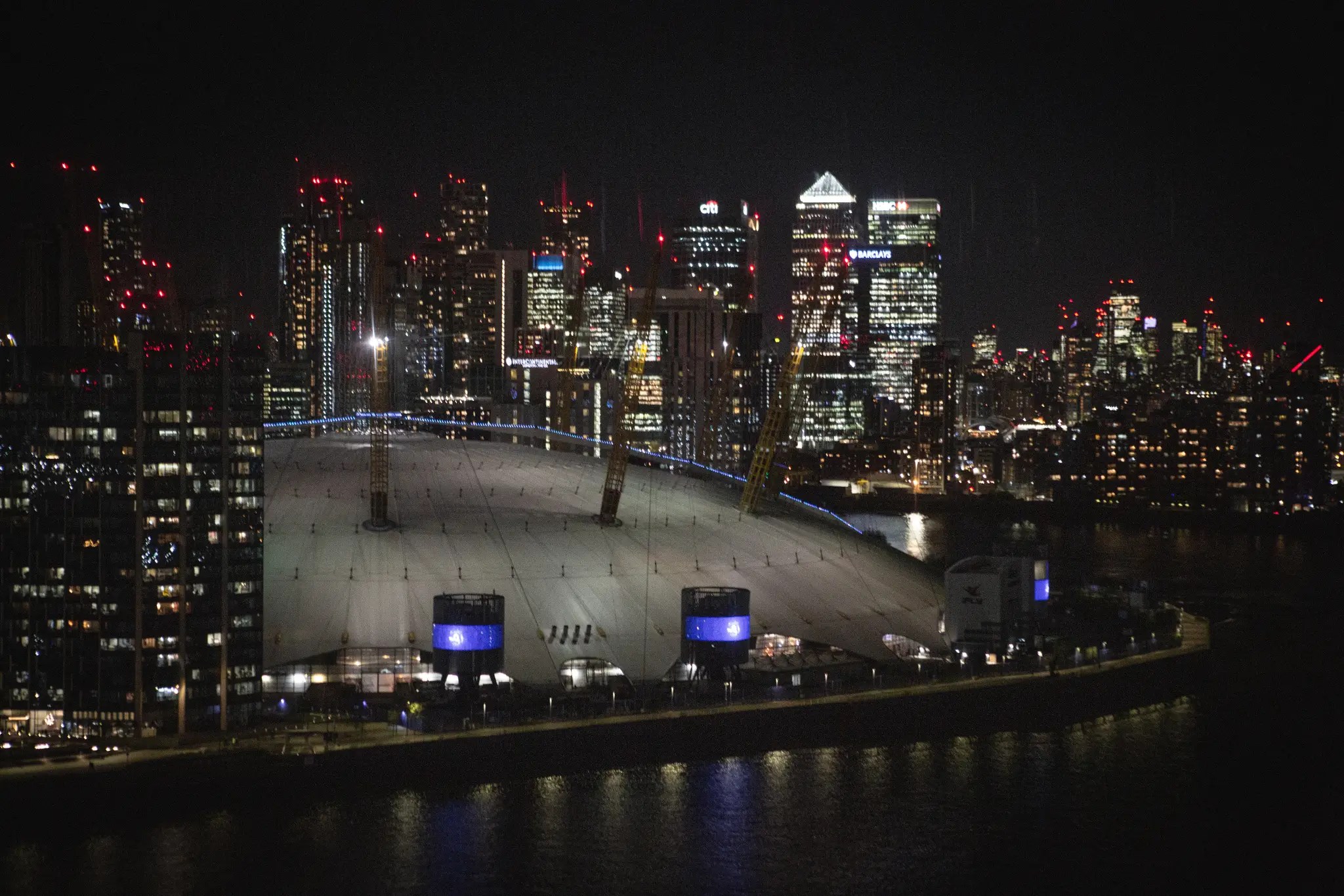
The last few kilometers are along the Thames Path, one of my favourite rides in all of London. The section around the O2 peninsula is particularly impressive, with epic views across the river towards Canary Wharf. Those endless fields you pedalled through over the last few days will feel a distant memory by this stage, deep in the urban sprawl.
Before long you’re back at Greenwich. The Cutty Sark is worth a tiny detour, before you climb the final hill back up to Greenwich Observatory. And that’s it! The Giant Circle is complete.
You can find my daily stages here, or the full route here. You can also find my personal experience of riding the route (in the blog’s usual style) here. If you do decide to give it a crack – please let me know!

Finally, here is a list of relevant train stations (compiled by someone who was mainly interested in useful connections to London, sorry!):
45km Dorking
73km Godalming
135km Winchester
175km Salisbury
265km Bristol
455km Shrewsbury (off-route)
520km Stoke-on-Trent (off-route)
565km Whatsandwell
575km Alfreton
585km Kirkby in Ashfield
620km Newark-on-Trent
700km Spalding
760km Ely
790km Newmarket

LikeLike
Thanks!
I actually made the route so long ago that by the time I ended up riding it I couldn’t quite remember how I made the main circle…
Essentially I found a way to create the geometric circle, converted it into a kml or perhaps a gpx. Then I split it, uploaded it into komoot so that it connected to roads, and then spent a lot of time trying to make it a nice ride. Did you have any luck? Sorry for the slow reply!
LikeLike
Thank you.
That*s the step I am struggling with…
LikeLike
Thanks for the route planning. Added another 100k and completed this as a 1000k DIY Audax. Here’s a link to my write up.
LikeLike
So cool! Congrats to you and Dave. Hope the route was OK?
Love reading your experience. Glad to see it is possible in the 3-day timeframe. It would be so cool to have it as an official audax event or route…
LikeLike